
From the Philippine News Agency (Aug 31, 2023): Philippines rejects new Chinese map showing PH features in WPS (By Joyce Ann L. Rocamora)
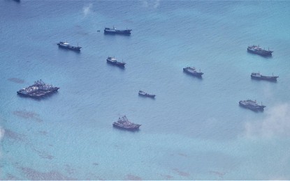
UNWANTED GUESTS. Chinese militia vessels are shown intruding in the vicinity of Kalayaan Island Group within the Philippine Exclusive Economic Zone (EEZ) on June 30. The Philippines on Thursday (Aug. 31, 2023) slammed China’s 2023 edition of its so-called “standard map” that still shows swaths of Philippine features in the West Philippine Sea. (Photo courtesy of Philippine Navy)
MANILA – The Philippine government on Thursday slammed China’s 2023 edition of its so-called “standard map” that still shows swaths of Philippine features in the West Philippine Sea.
The Chinese Ministry of Natural Resources issued on August 28 the controversial map that includes the nine-dash line, now a 10-dash line, that supposedly shows China’s boundaries in the South China Sea.
“This latest attempt to legitimize China’s purported sovereignty and jurisdiction over Philippine features and maritime zones has no basis under international law, particularly the 1982 United Nations Convention on the Law of the Sea (UNCLOS),” Foreign Affairs Spokesperson Ma. Teresita Daza said in a statement.
Daza said the 2016 Arbitral Award has already invalidated the nine-dashed line and called on China to abide by its obligations under UNCLOS.
“(The award) categorically stated that ‘maritime areas of the South China Sea encompassed by the relevant part of the ‘nine-dash line’ are contrary to the Convention and without lawful effect to the extent that they exceed the geographic and substantive limits of China’s maritime entitlements under the Convention,” Daza said.
“The Philippines, therefore, calls on China to act responsibly and abide by its obligations under UNCLOS and the final and binding 2016 Arbitral Award,” she added.
The Philippines is the latest nation to criticize Beijing’s publication of its more recent national map following India and Malaysia.
The said map also showed Arunachal Pradesh and the Doklam Plateau as well as the Aksai Chin that China controls but India claims.
India and China share a de facto border, parts of which are located in Arunachal Pradesh.
Manila had already protested the publication of a Chinese national map in 2013, which also placed parts of the Kalayaan Island Group or Spratlys within Beijing’s “national boundaries”.
According to a GMA News Online report that year, the Department of Foreign Affairs handed to the Chinese Embassy in Manila a June 7, 2013 note verbale, protesting China’s reference to the dash lines as part of its territory.
Daza has yet to respond to queries if the DFA lodged a new protest for the 2023 edition of the map.
Legislators take stand
Senators on Thursday rejected the “2023 standard map” of China showing a 10-dash-line that claims the West Philippine Sea as part of Chinese territory.
Senator Francis Escudero said Beijing's map "does not affect us nor does it impinges on the Arbitral Ruling in our favor."
"Any unilateral declaration by a State has no weight nor standing in international law," he said in a statement.
In a separate statement, Senate Minority Leader Aquilino Pimentel III said the Philippines is "not under any obligation to recognize the territorial claims of other countries."
"It is important to concentrate on our own position: on the extent of our territorial claims as well as maritime zones," he added.
Also, Senator Jinggoy Estrada said the Philippines must ignore any claims of China, adding: “Let them talk.”
Senator Risa Hontiveros, meanwhile, described the new map as Beijing's desperate attempt to assert its lies and propaganda, as she urged the Department of Foreign Affairs (DFA) to file formal protests, like what India and Malaysia did.
The “standard map” released by Beijing’s state-owned newspaper, Global Times, lays claim to a large part of the South China Sea, including the Philippines’ Exclusive Economic Zone in the West Philippine Sea.
It also emphasized Taiwan as well as India’s northeastern state of Arunachal Pradesh and Aksai Chin region as part of China’s domain.
Hontiveros recalled that on June 7, 2013, it was reported that DFA handed a confidential note verbale to the Chinese Embassy in Manila protesting China's publication of a “10-dash-line map” that year.
She said the agency should do the same for this recent map.
She said DFA should also coordinate with the National Resource and Mapping Authority to update a map that clearly shows our Exclusive Economic Zone, continental shelves, and territorial seas in the West Philippine Sea.
Meanwhile, senators are optimistic that China's new map showing a wider "10-dashed line" in the West Philippine Sea (WPS) will strengthen the Philippines' claim over its exclusive economic zone (EEZ) in the disputed area.
Senate President Juan Miguel Zubiri said the new claim of China will rally other countries like Malaysia, Indonesia, Vietnam, and even India that will eventually lead to crafting of the code of conduct in the disputed South China Sea.
"I think this way we will be able to galvanize more support from other countries. I think mas maraming bansa na ang susuporta sa stand ng Pilipinas (more countries will support the stand of the Philippines) to condemn and to appeal to China not to follow that ridiculous 10-dashed line because it violates the sovereignty of not only the Philippines now, but several countries all around the region," Zubiri told reporters.
Zubiri also said he was able to talk briefly with Philippine Special Envoy to China Ambassador Teodoro Locsin Jr. who vowed to exert more efforts both bilaterally and internationally to condemn the actions of China, and the repeated incursions, and the dangerous maneuvers in the WPS.
Maritime Zones Bill
Agreeing with Zubiri, Senator Francis Tolentino has called to execute the planned joint patrol with Japan, US, and Australia.
Tolentino also vowed to work on the deliberations and crafting of the Maritime Zones Bill.
"We’ll try to, as what SP [Senate President] said, fast-track the legislative measure that will call for the enactment of the Maritime Zone Bill," he said.
Zubiri committed earlier for the passage of the measure before the year ends.
"We will deliberate it during the budget deliberation. Isasabay namin tong Maritime Zones Act ni (We will also work on the Maritime Zones Act of) Senator Tolentino and several other senators [who] have filed [similar bills]. We're going to pass it," Zubiri said.
The measure aims to clearly determine the country's boundaries and its "shipping lines" that will help solidify its sovereignty.
It is also expected to strengthen the 2016 Arbitral Ruling and incorporate the tribunal's decision into legislation.
The Senate recently adopted a resolution creating the Special Senate Committee on Admiralty Matters that will "hear and sponsor all measures related to maritime zone bills as well as baseline acts." (With reports from Wilnard Bacelonia & Leonel Abasola/PNA)
https://www.pna.gov.ph/articles/1208895
No comments:
Post a Comment
Note: Only a member of this blog may post a comment.