
The Northern Luzon Command says the 1734 Murillo Map will always remind them 'that Scarborough Shoal is ours'
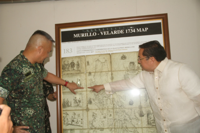
'SCARBOROUGH IS OURS.' The Northern Luzon Command on June 6, 2016, receives a framed replica of the 1734 Murillo Map that shows the disputed Panatag Shoal (Scarborough Shoal) as part of the Philippines. Photo courtesy of Northern Luzon Command
Soldiers in the
northern part of the Philippines
received on Monday, June 6, a framed replica of a 280-year-old map often used
to debunk China 's claims
over the West Philippine Sea (South China Sea ).
The replica of
the 1734 Murillo Map of the Philippines
Velarde gave the
replica to the Northern Luzon Command (Nolcom) of the Armed Forces of the Philippines
The 1734 Murillo
Map shows that the disputed Panatag
Shoal (Scarborough Shoal), also known as Bajo de Masinloc, has been
part of the Philippines
Panatag Shoal is
found in the contested West Philippine Sea .
(READ: Duterte: We will never surrender
Scarborough)
A standoff
between the Philippines and China in Panatag Shoal in April 2012 prompted Manila to file a historic case against Beijing
The case is
pending before an arbitral tribunal at the Permanent Court of Arbitration in The Hague , Netherlands
'Scarborough Shoal is ours'
Velarde said on
Monday: "Why is the replica of the Murillo Map being donated to the
Northern Luzon Command? The Northern Luzon Command is the protector, watcher,
caretaker, defender of Bajo de Masinloc under Northern Luzon Command's direct
jurisdiction."
The map was drawn
by a Spanish Jesuit priest, Father Pedro Murillo Velarde. Published in Manila , it is the first "internationally recognized
scientific map of the Philippines
Nolcom commander
Lieutenant General Romeo Tanalgo, for his part, praised Velarde for donating a
replica of the map to them.
Tanalgo said it
is a "unique and unmatched" act of patriotism to make sure that the
map "landed in the hands of Filipino people."
Nolcom said the
1734 Murillo Map will always remind them "that Scarborough Shoal is
ours."
In his lectures,
Senior Associate Justice Antonio Carpio of the Philippine Supreme Court has used ancient maps
to debunk China 's claim over
the West Philippine Sea .
Carpio has said
even China's ancient maps dating back to 960 AD show that its territory
"never included" the Spratly Islands and Scarborough Shoal in the
West Philippine Sea.
http://www.rappler.com/nation/135541-murillo-map-scarborough-shoal-nolcom-afp-donation-velarde
No comments:
Post a Comment
Note: Only a member of this blog may post a comment.