Satellite photos from a US-based think tank show progress in runway repairs and beaching ramp construction even as Chinese militia vessels surround the Philippines’ main outpost in the West Philippine Sea

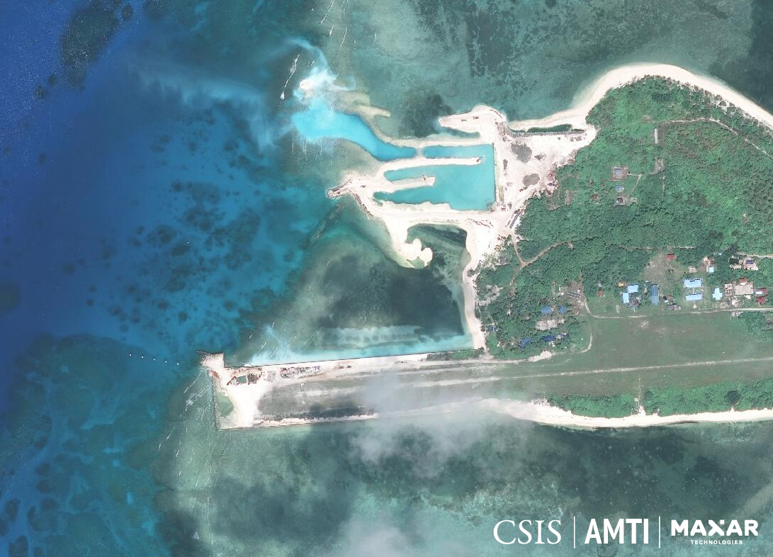
PROGRESS. THIS photo from the Asia Maritime Transparency Initiative of the Center for Strategic and International Studies (AMTI-CSIS) shows the progress of repairs and construction on Pag-asa Island in the West Philippine Sea. Photo from AMTI-CSIS
Chinese vessels that appear to be fishing boats but are more likely to be militias have surrounded Pag-asa (Thitu) Island in the West Philippine Sea for more than 450 days, as the Philippines quietly repairs and builds structures on its main outpost in the contentious waters.
Satellite photos released by the Asia Maritime Transparency Initiative (AMTI) of the Washington-based Center for Strategic and International Studies on Friday, March 6 (Philippines time), showed progress in repairing the sunken tip of the island’s airstrip, construction of a beaching ramp, and what appears to be dredging to create a harbor.
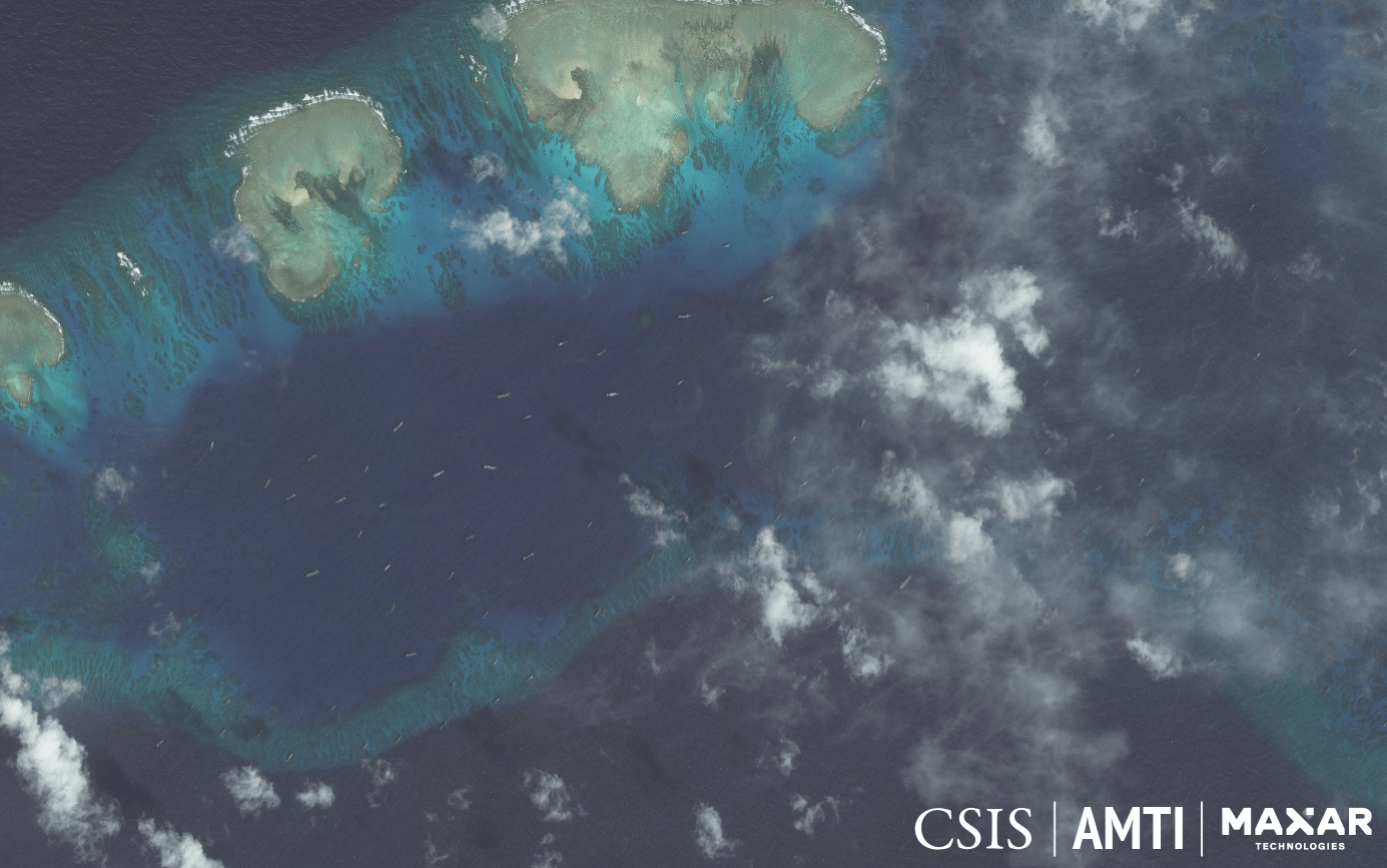
A study of the series of images also revealed that the Chinese militia boats have maintained a constant presence in the waters off the island and nearby sandbars since December 2018, shortly after construction work on Pag-asa began.

THE SWARM. The tiny specks on the water's surface in this satellite image are Chinese fishing boats whose constant, idle presence among the sandbars just off Pag-asa Island lead analysts to conclude they are militias. Photo from AMTI-CSIS
The runway on Pag-asa is unpaved, and it takes several days of zero rainfall to make the ground sturdy enough for landing airplanes. This makes scheduling flights to the island difficult and erratic.
Any effort to cement the runway would require that a collapsed portion on one end be repaired first.
The government is also building a beaching ramp on Pag-asa to receive shipments of materials and equipment for the construction work, as well as of supplies for the military and civilian residents on the island.
Actual work on the planned structures began in May 2018, and the progress has been plodding. Military and defense officials reported several delays due to the area’s unpredictable weather, but AMTI-CSIS said it was probably because of the Chinese vessels swarming the island.

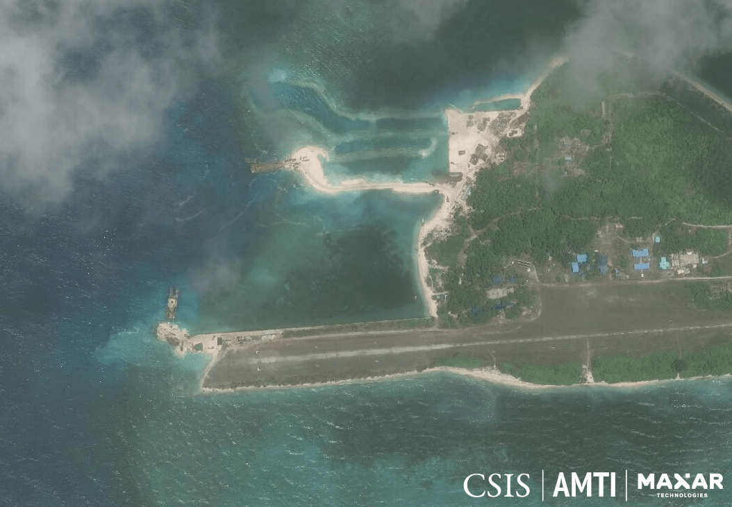
DREDGING. This image from June 2019 shows two barges doing dredging work on Pag-asa Island. One is repairing a sunken portion of the airstrip, while the other appears to be building a beaching ramp. Photo from AMTI-CSIS
Although their numbers fluctuated over the months, the Chinese fishing vessels maintained a constant presence near Pag-asa, with at least 18 vessels on any given day. Mostly idle, unmoving, and not actually fishing, the vessels were evidently militias, AMTI-CSIS said.
China Coast Guard ships and other larger vessels were also spotted prowling the area.
Pag-asa Island lies face-to-face with Zamora (Subi) Reef, which China has reclaimed and transformed into a full-fledged military base, with a 3-kilometer runway worthy of fighter jets and a large harbor for any kind of vessel. It is visible on the horizon from a tall viewing deck on Pag-asa, just 14 nautical miles away.

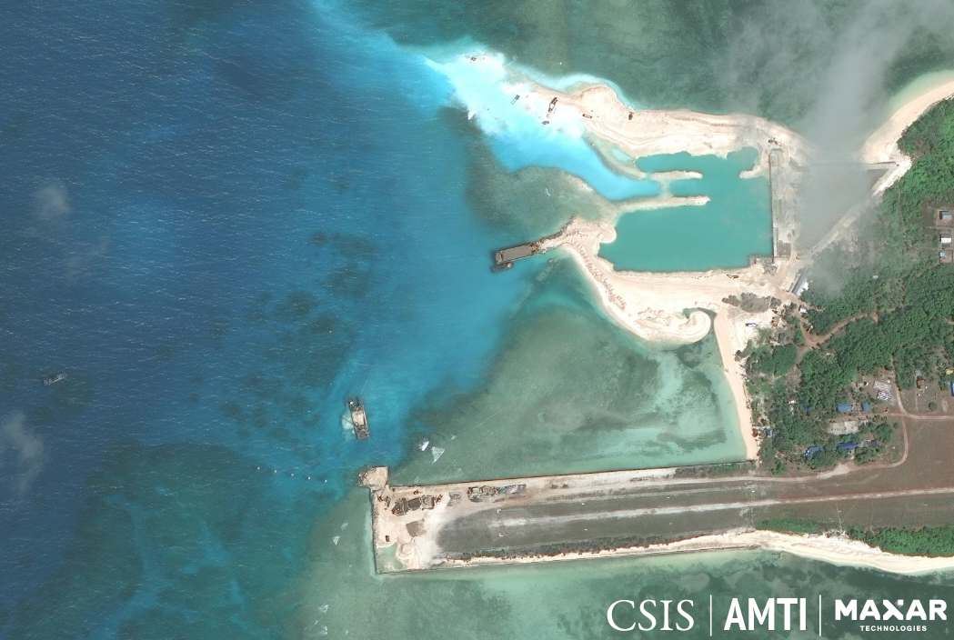
SLOWLY BUT SURELY. This satellite image from February 2020 shows significant progress in the repairs on Pag-asa's runway, and on the construction of a beaching ramp and a harbor nearby. Photo from AMTI-CSIS
Satellite photos released by the Asia Maritime Transparency Initiative (AMTI) of the Washington-based Center for Strategic and International Studies on Friday, March 6 (Philippines time), showed progress in repairing the sunken tip of the island’s airstrip, construction of a beaching ramp, and what appears to be dredging to create a harbor.
A study of the series of images also revealed that the Chinese militia boats have maintained a constant presence in the waters off the island and nearby sandbars since December 2018, shortly after construction work on Pag-asa began.

THE SWARM. The tiny specks on the water's surface in this satellite image are Chinese fishing boats whose constant, idle presence among the sandbars just off Pag-asa Island lead analysts to conclude they are militias. Photo from AMTI-CSIS
The Philippines announced plans to beef up Pag-asa as early as April 2017, when Defense Secretary Delfin Lorenzana visited the island with a group of reporters and photographers.
The runway on Pag-asa is unpaved, and it takes several days of zero rainfall to make the ground sturdy enough for landing airplanes. This makes scheduling flights to the island difficult and erratic.
Any effort to cement the runway would require that a collapsed portion on one end be repaired first.
The government is also building a beaching ramp on Pag-asa to receive shipments of materials and equipment for the construction work, as well as of supplies for the military and civilian residents on the island.
Actual work on the planned structures began in May 2018, and the progress has been plodding. Military and defense officials reported several delays due to the area’s unpredictable weather, but AMTI-CSIS said it was probably because of the Chinese vessels swarming the island.

DREDGING. This image from June 2019 shows two barges doing dredging work on Pag-asa Island. One is repairing a sunken portion of the airstrip, while the other appears to be building a beaching ramp. Photo from AMTI-CSIS
The Department of National Defense reported the presence of at least 322 individual Chinese vessels in 2018 and 2019, and commented that while they appeared to be fishing boats, their behavior indicated that they could be militias, a paramilitary force functioning for China’s strategic gain.
Although their numbers fluctuated over the months, the Chinese fishing vessels maintained a constant presence near Pag-asa, with at least 18 vessels on any given day. Mostly idle, unmoving, and not actually fishing, the vessels were evidently militias, AMTI-CSIS said.
China Coast Guard ships and other larger vessels were also spotted prowling the area.
Pag-asa Island lies face-to-face with Zamora (Subi) Reef, which China has reclaimed and transformed into a full-fledged military base, with a 3-kilometer runway worthy of fighter jets and a large harbor for any kind of vessel. It is visible on the horizon from a tall viewing deck on Pag-asa, just 14 nautical miles away.

SLOWLY BUT SURELY. This satellite image from February 2020 shows significant progress in the repairs on Pag-asa's runway, and on the construction of a beaching ramp and a harbor nearby. Photo from AMTI-CSIS
The Armed Forces of the Philippines recently reported sighting 136 individual Chinese vessels around Pag-asa. On Tuesday, March 3, National Security Adviser Hermogenes Esperon Jr said the Chinese vessels were likely to remain indefinitely in the waters near the island, what with a formidable base on nearby Zamora Reef.
Upgrading the features on Pag-asa Island is the first concrete move in the Philippines’ plan to wield a more consistent presence among the Kalayaan Island Group – the 9 islets it possesses among the Spratlys in the West Philippine Sea.
https://www.rappler.com/nation/253691-look-swarm-chinese-boats-philippines-building-pagasa-island

No comments:
Post a Comment
Note: Only a member of this blog may post a comment.