
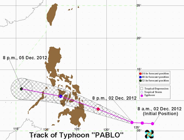
Typhoon "Pablo"accelerated after entering the Philippine Area of Responsibility (PAR) and storm signal #1 was raised over 18 provinces in Mindanao and Visayas on Sunday, December 2. In its 11 pm bulletin, weather bureau PAGASA announced that as of 10pm Pablo (international codename: Bopha) was located 810 kilometers (km) Southeast of Hinatuan, Surigao del Sur (6.4°N, 134.0°E). The typhoon is packing maximum sustained winds of 185 km per hour and gusts of up to 220 km/h, and moving west northwest at 26 km/h. PAGASA chief weather forecaster Robert Sawi earlier said that Pablo would make landfall in northern Mindanao or eastern Visayas Tuesday, December 4.
Mindanao, Visayas to be hit
Pablo is forecast to pass through central Visayas toward Panay, then northern Palawan and Mindoro before exiting the country into the South China Sea (West Philippine Sea). Heavy to intense rainfall (20-30 millimeters per hour) is expected within the typhoon's 700 km diameter, and large parts of Mindanao and Visayas should prepare for floods and landslides. Public storm signal warning #1 (45-60 km/h winds in the next 36 hours) is in place over 18 provinces in Mindanao and Visayas:
- Surigao del Sur
- Surigao del Norte including Siargao Island
- Dinagat Island
- Agusan del Norte
- Agusan del Sur
- Davao Oriental
- Davao del Norte inluding Samal Island
- Compostela Valley
- Bukidnon
- Misamis Oriental
- Camiguin
- Bohol
- Biliran
- Camotes Island
- Southern Leyte
- Leyte
- Eastern Samar
- Western Samar
http://www.rappler.com/nation/17136-storm-signal-1-over-18-provinces
No comments:
Post a Comment
Note: Only a member of this blog may post a comment.